


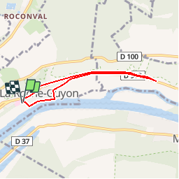
La Roche Guyon 5.3 km

GOELERANDO2
User

Length
5.3 km

Max alt
45 m

Uphill gradient
55 m
Km-Effort
6.1 km

Min alt
15 m

Downhill gradient
56 m
Boucle
Yes
Creation date :
2017-03-13 00:00:00.0
Updated on :
2017-03-13 00:00:00.0
1h29
Difficulty : Easy

FREE GPS app for hiking
 SityTrail
IGN / Geographical institutes
SityTrail Plus
The world is yours!
About
Trail Walking of 5.3 km to be discovered at Ile-de-France, Val-d'Oise, La Roche-Guyon. This trail is proposed by GOELERANDO2.
Description
Au départ du parking du Château, jusqu'à l'Eglise de Haute Isle et retour.
Positioning
Country:
France
Region :
Ile-de-France
Department/Province :
Val-d'Oise
Municipality :
La Roche-Guyon
Location:
Unknown
Start:(Dec)
Start:(UTM)
399728 ; 5437222 (31U) N.
Comments